2-18-15
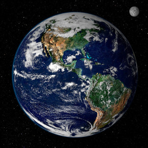
NASA archive image, relase date October 17, 2000.
This true-color image shows North and South America as they would appear from space 35,000 km (22,000 miles) above the Earth. The image is a combination of data from two satellites. The Moderate Resolution Imaging Spectroradiometer (MODIS) instrument aboard NASA’s Terra satellite collected the land surface data over 16 days, while NOAA’s Geostationary Operational Environmental Satellite (GOES) produced a snapshot of the Earth’s clouds.
Image created by Reto Stöckli, Nazmi El Saleous, and Marit Jentoft-Nilsen, NASA GSFC
Credit: NASA Earth Observatory
NASA Goddard Space Flight Center enables NASA’s mission through four scientific endeavors: Earth Science, Heliophysics, Solar System Exploration, and Astrophysics. Goddard plays a leading role in NASA’s accomplishments by contributing compelling scientific knowledge to advance the Agency’s mission.
Follow us on Twitter
Like us on Facebook
Find us on Instagram


Leave a Reply
Want to join the discussion?Feel free to contribute!